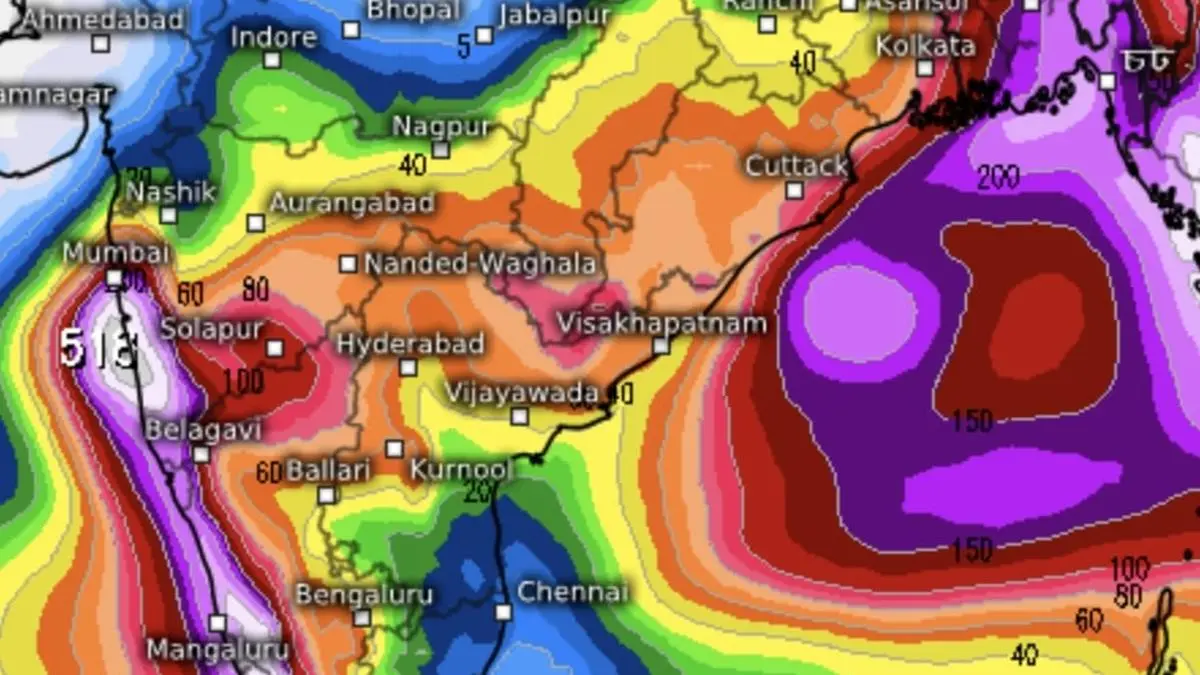

European Centre for Medium-Range Weather Forecasts sees very heavy rain along the west coast, adjoining interior peninsula and North-East India as the monsoon fires away during the course of this week.
| Photo Credit:
www.meteologix.com/in
A rain-driving low-pressure area, remnant from erstwhile depression, persisted on Monday over Marathwada along with a few juvenile cohorts over both land and Arabian Sea, the Bay of Bengal threatening to lob its own into the monsoon playground.
India Meteorological Department (IMD) maintained that a fresh low-pressure area, second system to emerge since monsoon onset two days ago, will pop over west-central and adjoining north Bay along north Andhra Pradesh-Odisha coast by Tuesday.
Surplus moisture
They will together ensure humongous amount of moisture to slosh around over west coast as well as adjoining interior peninsula, resulting in heavy to very heavy to extremely rain at various places over past purple of days as during past couple of days.
Monsoon may let off some steam thereafter likely bringing and eventful onset stage. This will come about after projected ‘low’ over the Bay of Bengal crosses West Bengal/Bangladesh coast and spends itself out over hills of West Bengal and Sikkim, says an outlook from the European Centre for Medium-Range Weather Forecast.
Barren winds likely?
IMD’s numerical predictions appear to agree with this, suggesting barren westerly to north-westerly winds may take charge over North-West India and East India. In the meantime, it appears Delhi and West Uttar Pradesh will have been pulverised by another cyclonic circulation and resultant stormy weather from a passing western disturbance.
A counterpart system had caught an IndiGo flight in a dangerous hail storm a couple of days, which managed to land safely in Srinagar. Chennai-based Ramachandran Seshadri (@seshchandran), a Vedic meteorologist, claimed he had predicted a year ago the possibility of ‘turbulence and related incidents’ in this airspace from mid-May till mid-July this year.
Turbulence forecast
He had said in a post on X on May 26, 2024, that ‘turbulence will’ manifest ‘after sunset/before sunrise rise’ and advised flights to avoid airspace beyond the 23º North latitude (corresponding Palampur, Mandsaur, Biaora, Sagar and Shahdol, Ambikapur and Jamshedpur) from second week to end of May this year; and from second week of June to second week of July.
Published on May 26, 2025
Anurag Dhole is a seasoned journalist and content writer with a passion for delivering timely, accurate, and engaging stories. With over 8 years of experience in digital media, she covers a wide range of topics—from breaking news and politics to business insights and cultural trends. Jane's writing style blends clarity with depth, aiming to inform and inspire readers in a fast-paced media landscape. When she’s not chasing stories, she’s likely reading investigative features or exploring local cafés for her next writing spot.
- ANURAG DHOLEhttps://indiatadkha.com/author/bitlancetechhubgmail-com/

- ANURAG DHOLEhttps://indiatadkha.com/author/bitlancetechhubgmail-com/
- ANURAG DHOLEhttps://indiatadkha.com/author/bitlancetechhubgmail-com/
- ANURAG DHOLEhttps://indiatadkha.com/author/bitlancetechhubgmail-com/